Real-time hydraulic model integration closes the gap on digital twins
Municipal stormwater departments invest years of engineering effort in SWMM, InfoWorks and MIKE models — then leave them dormant between projects, producing static reports that are outdated the moment they are printed.
Municipal stormwater departments invest significantly in hydraulic models. These SWMM, InfoWorks or MIKE models represent years of engineering effort, calibrated against monitoring data, validated through design storms and refined through successive planning studies. Yet for most utilities these models sit dormant between projects, producing static reports that become outdated the moment they are printed.
The problem is not the models themselves. It is how we use them.
When a major storm approaches, operators check rain gauges and sensor levels, not model predictions. When green infrastructure is installed across a watershed, years pass before anyone re-runs the model to assess its impact. When a sensor fouls or drifts, it may go unnoticed until the next calibration cycle, if there is one.
What if these models could run continuously, automatically comparing predictions against live sensor data? What if the same interface operators use for monitoring could also show them what the model expects to happen, and alert them when reality diverges from prediction?
This is no longer theoretical. A recent project in the Metro Vancouver region demonstrates that integrating hydraulic models with real-time monitoring platforms delivers practical operational benefits today, using tools accessible to utilities of any size.
From planning tool to operational asset
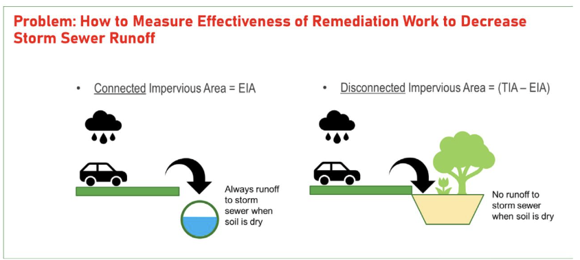
The project began with straightforward questions. The municipality had been implementing green infrastructure across a fully urbanized watershed for nearly two decades — rain gardens, green roofs and impervious area disconnections, installed through both private redevelopment and public capital programs. But how could they measure whether these investments were actually working?
They also wanted to know whether a real-time model could provide alarms at ungauged locations, particularly at critical culvert crossings where capacity exceedances could cause flooding. Could the model detect when flow monitoring sensors fouled or drifted? And could it provide flow forecasts based on weather predictions?
Kerr Wood Leidal Associates Ltd. (KWL), a Vancouver-based consulting engineering firm, had maintained the watershed's SWMM model since the 1990s. The model was well-calibrated to historical monitoring data and had been used for numerous planning studies. The question was whether it could be brought online to run continuously.
The integration was accomplished through FACE Pro. The technical approach was straightforward: Python scripts download real-time and forecasted climate data from online sources, execute the SWMM model, and push the results back into infinitii flowworks where they appear alongside live sensor data.
The entire integration took weeks rather than months. No custom software development was required — just configuration of existing tools and adaptation of the client's calibrated model.
Operational benefits in practice
Flood forecasting became possible by feeding seven-day weather forecasts into the model. Operators could see predicted flows at any location in the drainage network, not just where sensors were installed. For a watershed with steep terrain and flashy hydrology, this advance warning proved particularly valuable.
Alarms at ungauged locations addressed a critical gap. The watershed had flow monitoring at its outlet, but several upstream culvert crossings had known capacity constraints. The model now provides continuous flow estimates at these locations, triggering alerts when predicted flows approach or exceed design capacity. That capability would traditionally require installing additional monitoring equipment, with the capital and maintenance cost that implies.
Sensor validation emerged as an unexpected benefit. When model predictions consistently diverge from sensor readings under conditions where they should agree, it often indicates fouling, drift or malfunction. Operations staff now have an automated cross-check that flags potential sensor issues for investigation.
All of these capabilities appear within the same infinitii flowworks interface staff already use for routine monitoring. There was no new system to learn and no additional login to manage. The model outputs simply became another data source alongside the existing sensors.
Measuring green infrastructure effectiveness
The most compelling outcome was not planned as an operational feature. It emerged from the decision to keep the model calibrated to historical conditions rather than updating it to reflect current watershed characteristics.
KWL had calibrated the model to flow monitoring data from 2010, before most of the green infrastructure had been implemented. When the model was brought online and began running against current sensor data, a clear pattern emerged.
During winter storms, when soils are saturated and green infrastructure provides minimal benefit, the model predictions matched observed flows closely. The calibration remained valid. During spring and summer storms, however, the model consistently over-predicted flows.
This divergence was not a calibration failure. It was evidence that the green infrastructure was working. When soils are dry, rain gardens and disconnected impervious areas absorb and infiltrate rainfall that would previously have run off directly to the storm system. The model, still representing the historical watershed, predicted what flows would have been without these improvements. The difference between prediction and observation quantified the runoff reduction achieved.
Using calibration drift as a measurement tool provides something green infrastructure programs often struggle to demonstrate: empirical, continuous evidence of performance. The engineering team has since begun updating the calibration to match current conditions, systematically increasing impervious disconnection parameters until predictions align with observations. Early results suggest the effective impervious area has dropped from approximately 50% to the mid-20s — a substantial reduction attributable to two decades of green infrastructure implementation.
Closing the gap on expensive digital twin capability
Projects like this would traditionally require significant custom development, specialized real-time modelling software, or expensive digital twin platforms marketed primarily to large utilities. The tools used here — an existing SWMM model, a standard monitoring platform and a Python scripting engine — represent a fraction of that cost and complexity.
That accessibility matters. Most municipalities are not large enough to justify enterprise-scale digital twin investments. But they do have hydraulic models developed through master planning studies, and they do have monitoring data flowing into operational platforms. The gap between these assets is narrower than many realize.
Similar integrations have since been completed using other modelling tools, including UBC's Raven watershed model and the Soil and Water Assessment Tool (SWAT).
Implications for practice
Rather than assets that produce periodic reports, models become continuous operational tools that generate value daily. A model running continuously against live data will reveal calibration issues faster than periodic studies. It will identify locations where actual system behaviour differs from design assumptions. It will provide a framework for evaluating any intervention — green infrastructure, pipe rehabilitation or operational change.
Perhaps most importantly, it makes the model's predictions visible and testable. When operators can see model outputs alongside sensor data every day, they develop intuition about where the model performs well and where it needs refinement. The model becomes a living tool rather than a static artifact.
For utilities considering this approach, the technical barriers are lower than they may appear. The critical requirements are a calibrated model, a monitoring platform capable of hosting custom scripts, and engineering expertise to configure and validate the integration.
Acknowledgment: the hydraulic model integration described here was designed and implemented by Kerr Wood Leidal Associates Ltd. (KWL), with Jeff Marvin, M.A.Sc., P.Eng. serving as project lead.
First published on the infinitii ai blog. infinitii ai is the company behind infinitii flowworks.
Related
Streamflow and forecasting
Model integration, continuous simulation and discharge prediction.
See it on your own data
A walkthrough on your own sites answers the questions an article cannot.